![]()

CHERISH is a six-year Ireland-Wales project, bringing together four partners across two nations: the Royal Commission on the Ancient and Historical Monuments of Wales; the Discovery Programme, Ireland; Aberystwyth University: Department of Geography and Earth Sciences; and Geological Survey Ireland. The project began in January 2017 and will run until December 2022. It will benefit from €4.9 million of EU funds through the Ireland Wales Co-operation Programme 2014-2020.
CHERISH is a truly cross-disciplinary project aimed at raising awareness and understanding of the past, present and near-future impacts of climate change, storminess and extreme weather events on the rich cultural heritage of our sea and coast. CHERISH links land and sea and employs a variety of techniques and methods to study some of the most iconic coastal locations in Ireland and Wales. These range from terrestrial and aerial laser scanning, geophysical survey and seabed mapping, through to paleoenvironmental sampling, excavation and shipwreck monitoring.
The main objective of CHERISH is to increase capacity and knowledge of climate change adaptation for the Irish Sea and Coastal communities.
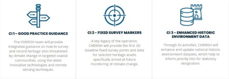
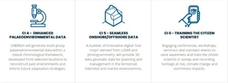
This is being achieved through the following nine CHERISH Initiatives (CI):
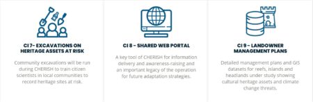
The excavation at Caerfai Promontory Fort will help to deliver CI7 – Excavations on Heritage Assets as Risk.
Click through to the CHERISH project website to find out more: